 |
| Here's life - a bra ad - and death - notices of death pasted over them. In Castel Gandolfo (summer home of the Popes - and featured in the award-winning 2019 film, "The Two Popes"). "In forma smagliante" is a sort of double entendre here, trans. "In great shape" "In top form" "Fit as a fiddle" etc. |


On the "life" side (mostly), right - "Brigata Peroni" or "Peroni [as in the beer] Brigade." One doesn't normally associate brigades, as in armed forces or the anarchical - and deadly (they killed Aldo Moro)- leftists, the "Red Brigade," with beer.

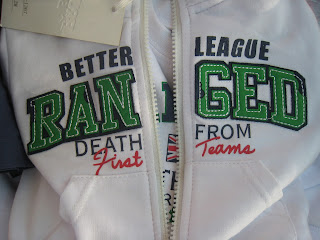 Okay - we've posted photos of the nonsensical writings on shirts and jackets, but we think not this one, which does have the word "death" in it - seen in a Rome market. I just finished reading Bill Bryson's "The Mother Tongue: English and How It Got That Way" in which he quotes some of these. None is better than this one at right.

For the death end, here are two photos from the top of a mountain an hour or two outside Rome in the Abruzzi (the Gran Sasso). Yes, the ubiquitous cross was there, but also Mary, complete with rosary, and several plaques to hikers who had gone on to other heights.

Left, a fully-stocked outdoor bar/cafe', complete with the requisite photo of iconic actor Alberto Sordi, in the iconic still of him eating spaghetti (from the film "Un Americano a Roma") - we've probably seen a hundred of these in restaurants and cafes and bars - and books!
 Okay - we've posted photos of the nonsensical writings on shirts and jackets, but we think not this one, which does have the word "death" in it - seen in a Rome market. I just finished reading Bill Bryson's "The Mother Tongue: English and How It Got That Way" in which he quotes some of these. None is better than this one at right.
 |
| Eating IN the streets of Trastevere. This could be a good model for restaurants in the US trying to expand their outside service. Not exactly social distancing. And no worries from those actually standing in the street that they could be run over. |

For the death end, here are two photos from the top of a mountain an hour or two outside Rome in the Abruzzi (the Gran Sasso). Yes, the ubiquitous cross was there, but also Mary, complete with rosary, and several plaques to hikers who had gone on to other heights.
In the photo below, the plaque on the right says, "Friendship doesn't need time or space. We know you will always be at our side. Ciao Nicola."
And in that same photo, the plaque on the left reads, "In memory of Ezio Noce. Your mountain friends affectionately remember you, in this place familiar to you."

Dianne


